
Return to Beaufort County NCGenWeb Home Page
Return
to Beaufort County NCGenWeb Home Page
![]()
Survey of Bath
Creek - 1840
Source: Special Collections, Joyner
Library, East Carolina University
![]()
From early on, Bath was defined by land transactions. The following is a mid-nineteenth-century survey of lands that includes mention of eighteenth-century ownership of the land going back to 1722. The Glebe Land (land owned by St. Thomas Episcopal Church to help support the minister) is directly across from the town of Bath.
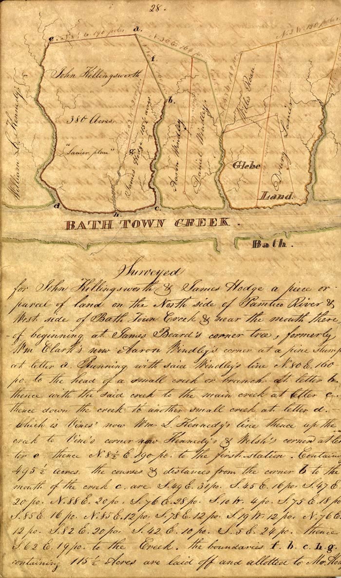 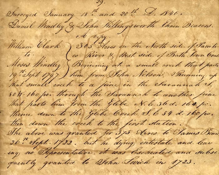 [page 28] [survey map] Surveyed for John Killingsworth & James Hodge a piece or parcel of land on the North side of the Pamlico River & West side of Bath Town Creek & near the mouth there, of beginning at James Beard’s corner tree, formerly Wm Clark’s now Aaron Windley’s corner at a pine stump at letter a. Running with said Windley’s line N. 80 E. 160 po. [poles] to the head of a small creek or branch at letter b. thence with the said creek to the main creek at letter c. thence down the creek to another small creek at letter d. which is Vines’ now Wm. L. Kennedy’s & Welsh’s corner at letter e. thence N. 8 1/2 E. 190 po. to the first station. Containing 495 1/2 acres. the courses & distances are S. 49 E. 31 po. S. 45 E 16 po. S 47 E. 20 po. N. 88 E. 20 po. S. 76 E. 28 po. S. 10 W. 4 po. S. 75 E. 18 po[.] S. 85 E. 16 po. N. 85 E. 12 po. S. 78 E. 12 po. S. 19 W. 12 po. N. 76 E. 12 po. S. 82 E. 20 po. S. 42 E.10 po. S. 5 E. 24 po. Thence S. 62 E. 19 po. To the Creek. the boundaries f. b. c. h. g. containing 115 1/2 Acres are laid off and allotted to Mr. Hod[ge]. [page 29] Surveyed January 18th and 20th A. [Anno] 1840. Daniel Windley & John Killingsworth Chain Bearers. A Copy William Clark To Moses Windley 19th September 1797 305 Acres on the North side of Pamtico River & West side of Bath Town Creek[.] Beginning at a small creek that parts him from John Nelson. Running up that small creek to a line in the Savannah S. 80 W. 160 po. through the Savannah to another pine that parts him from the Glebe N.E. 36 d. 164 po. Thence down to the Glebe Creek S. E. 54 d. 160 po. Then down the creek to the first section. The above was granted 375 Acres to James Beard 26th Sept. 1722, but he dying intestate and leaving no Representative, it was Escheated and subsequently granted to John Lovick in 1723. |
![]()
Copyright 2009 Kay Midgett Sheppard
![]()